

3 Methods to Calculate Distance Between Different Locations
Edited by Caroline Ryan | Feb 17, 2025 | Virtual Location
To measure one’s distance or location between two or more endpoints, the user must be familiar with or at least know how to do it, as there can be plenty of ways to do it. Little did every user know that among the variations of methods to calculate distance different approaches are needed for different purposes. If you are using a mobile device to calculate a specified distance between locations there are effective ways to do it only by your mobile device, on the other hand, if you use desktop devices then there are different approaches to doing it as well. In addition, if you use both devices, we also have listed methods for using a third-party tool. If you are new to such a task, this guide is also for you. We list three methods to help you calculate distance utilizing your Google Maps features, mobile devices, and a software tool for your desktop with promising features. This guide will introduce you to this method and teach you step-by-step how to do the task effectively.
Contents:
Part 1. How To Measure Distance on Google Maps
To measure distance on Google Maps, users must perform the following steps effectively and without breaking a sweat. The method that we listed here can be performed on both your mobile devices through the Google Maps app or your desktop device through your web browser Google Maps. Thus, it is up to the user on what method to use to calculate distance as we have two ways to calculate distance using Google Maps direction feature or distance feature.
Measure Distance Using Direction Feature
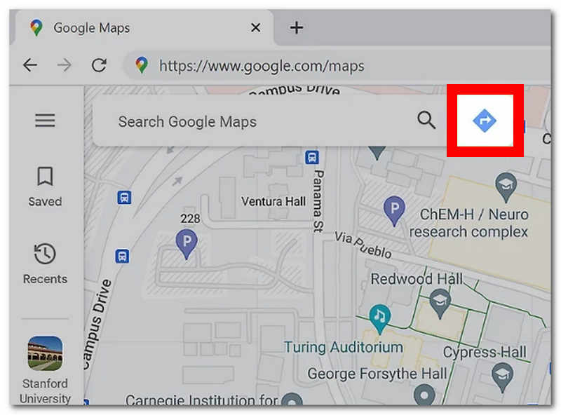
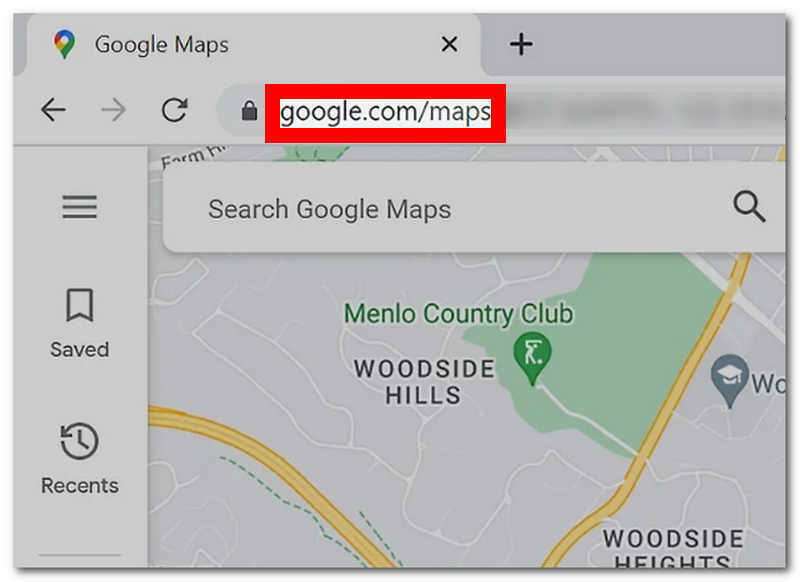
Step 1. To measure distance in Google Maps through its direction features, go to https://www.google.com/maps in any browser.

Step 2. Once in the Google Map interface, click the Direction button beside the search bar field.
Step 3. After clicking the Direction button, a field for both the starting and end locations will appear on your screen. From there, enter the area where you want to measure distance.
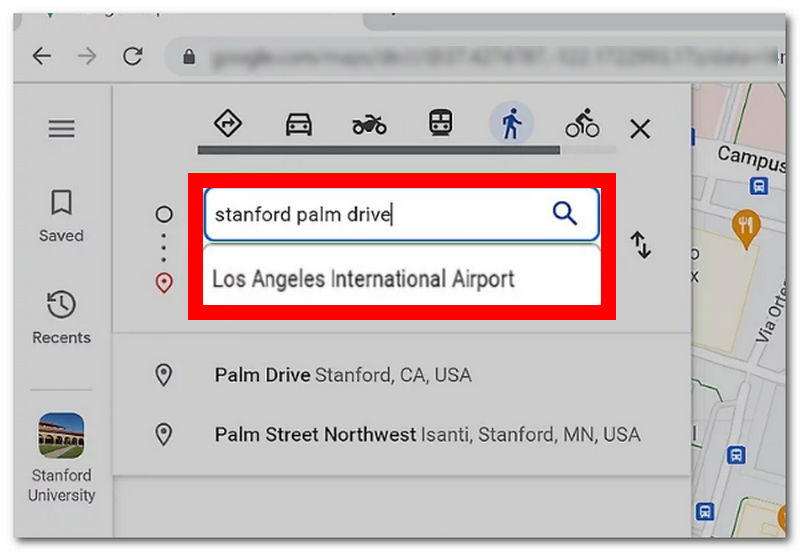
Note: You can enter two or more locations to measure their distance in Google Map
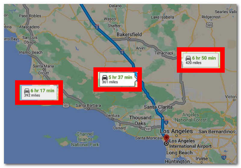
Step 4. Once you successfully enter all the locations in Google Maps, it will automatically show you the distance and estimated travel time to each area.
Measure Distance Using Distance Feature
Step 1. From any of your desired web browsers, go to https://www.google.com/maps.
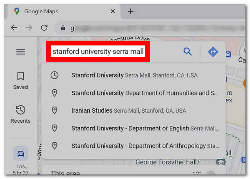
Step 2. Click on the search bar in Google Maps, enter the location or area from which you want to measure distance, and press the Enter button on your keyboard.
Step 3. The virtual location will automatically go to the Google Maps interface area. Locate the red pin in the virtual map and right-click on your mouse to select the Measure Distance feature.
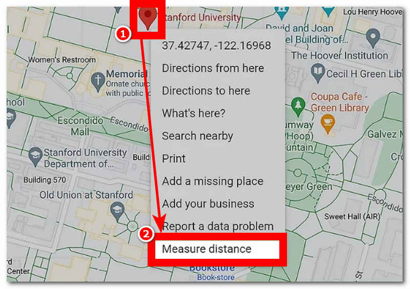
Step 4. Once you click on Measure Distance, you can select an endpoint from anywhere on the virtual map, and from that endpoint, you can see the calculated distance between the two locations.
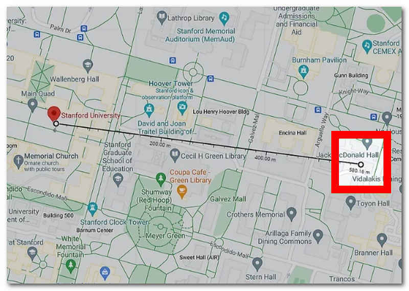
Note: Unlike the Direction Features, this method omits routes and buildings. As a result, it displays the shortest distance without considering the possibility of following it due to the presence of establishments and other facilities along the way.
Part 2. Measure Distance on iPhone
To measure distance on a map using your mobile device, in this case, iPhone devices, users can effectively do it by opening the map app pre-installed on their device. Doing it through your iPhone’s built-in map is also possible. Thus, simply follow the steps below for seamless distance measuring.
Step 1. On your iPhone, open your Map app.
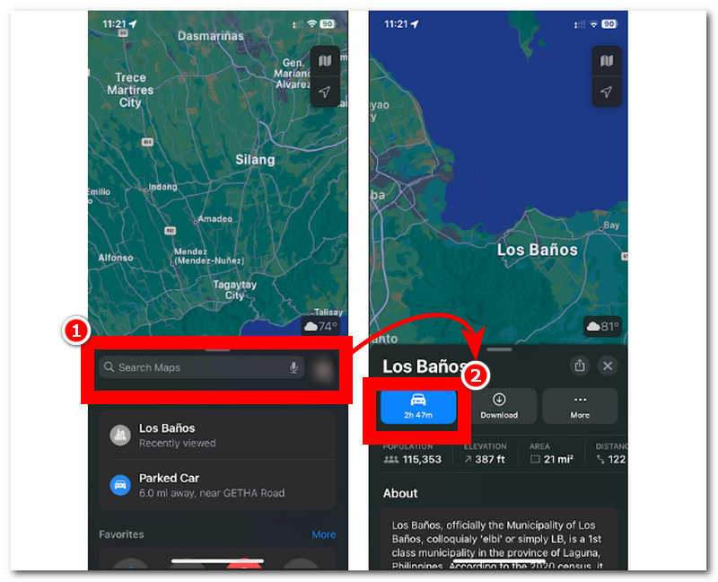
Step 2. Within your iPhone's Maps interface, locate the search bar and type in the location or area from which you want to measure distance.
Step 3. Once you search for the location you have in mind, the results will show you the location information. To better understand that location's distance and travel time, click the Drive button underneath the location's name.
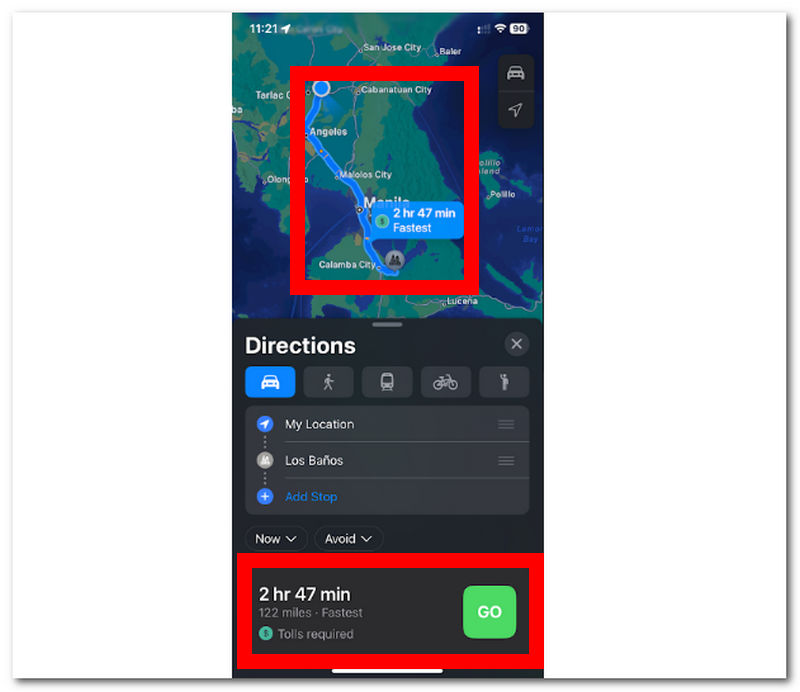
Step 4. It will display the fastest, actual, passable route users may follow to get to that location.
Part 3. Calculate Distance Easily
If you find the abovementioned method handy and challenging, then you will like this last method we will show you. This method uses a lightweight program for your desktop devices called AnyCoord, which is accessible yet free to install. This full-featured software can calculate distance from anywhere around the world as it utilizes modern technology to be exact artificial intelligent, which a lot of software tools also use, but what sets AnyCoord from the rest of its competitors is that it also integrates GPS technology to have a real-time and accurate view of the world virtually.
This software can calculate distance and manipulate a user’s location. It appears to help set up a user’s virtual location to access apps, games, content, and platforms that are geo-restricted. AnyCoord has a simple user interface that appeals to non-tech-savvy and professional users while offering various features for virtual location and measuring distance tasks.
Key Features
• It shows an accurate location distance.
• It can measure the distance of multiple locations in one go.
• Includes distance coordinates for the precise point of location.
• It can show users' arrival time to each endpoint.
• Travel speed information is also possible.
• It can set a virtual location to access location-based games and apps.
• Supported a vast number of platforms, games, and applications.
• It has four AI modes for different location tasks and needs.
• Highly safe, full-featured, distanced calculator.
Step 1. Have AnyCoord software downloaded to your desktop device through their official website, or use the quick download link below. Once done downloading, launch the software from your desktop and connect your mobile device to your desktop through a cable.
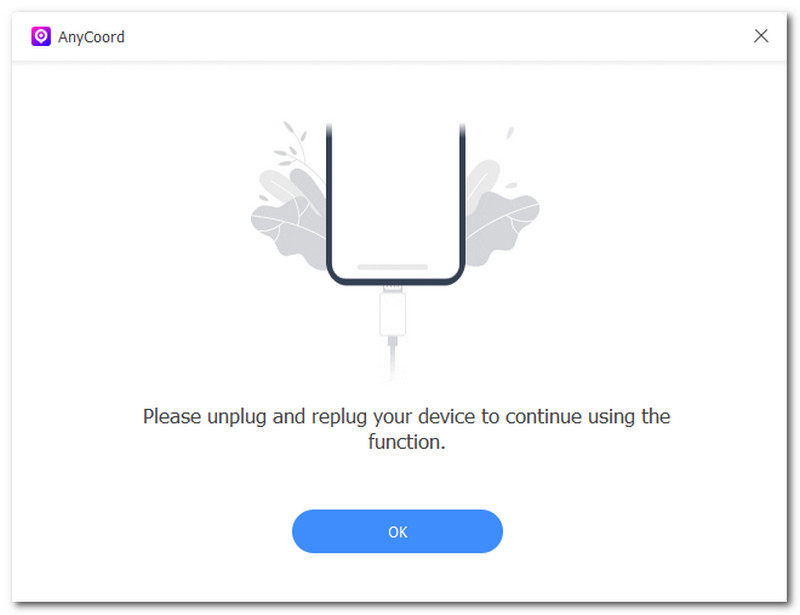
Note: Connecting your mobile device to your desktop through a cable is crucial for proceeding, viewing, and measuring the distance to a location.
100% Secure & Clean
100% Secure & Clean
Step 2. Once you have connected your mobile device, the software’s interface will show you the four AI modes available for different virtual location tasks. To measure or calculate distance, simply click the Modify Location, One-stop, and Multi-stop modes.
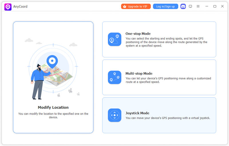
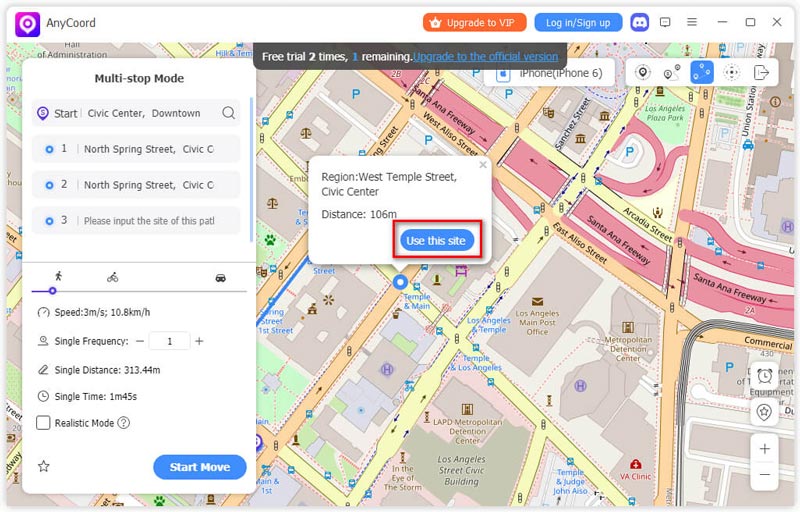
Note: Modifying Location Mode is the easiest way to display distance information instantly. One-stop Mode allows users to view distance information with start and end points and display speed information. Multi-stop Mode will enable users to view distance information with two or more endpoints while displaying their calculated distance and travel speed.
Step 3. Once you have chosen your AI modes, use the search bar field to find the starting and end points for calculating distance and travel speed.
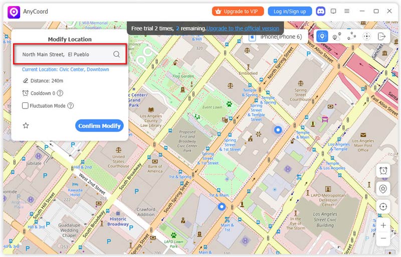
Step 4. Click the Use this Site button to use the entered location as your starting and ending point. Once you have done this, you may see all the information about your location distance (Distance, Speed, and Coordinates).
Now, you had to obtain the ability to use AnyCoord to change your virtual location; what’s more, this tool not only change virtual location of games, even more it can change your location of iPhone to protect your privacy.
Part 4. FAQs about How to Measure Distance
-
1Can your phone track distance?
Yes, most mobile phones can track distance using GPS and motion sensors. Thus, these mobile phones track distance through fitness apps based on tracking the distance in the user's steps from one location to another.
-
2How to measure walking distance on a phone?
A walking distance-tracking application, such as a fitness or health app, should measure a user’s walking distance using only their mobile devices.
-
3What is the most accurate way to measure distance?
The accurate way to measure the distance between different locations is by using a GPS-based app or software. Like the AnyCoord software, it uses GPS to obtain real-time data on the world map, which results in accurate distance information and provides users with a precise travel distance speed.
-
4Can I measure walking or driving distances?
Yes, many platforms, such as pre-installed Maps in iPhone, Google Maps, and even AnyCoord, can effectively measure distances between two or more locations, whether in walking or driving mode. All of them use passable routes to determine the distance information. However, the information displayed on walking differs from that on driving regarding the estimated arrival time.
-
5Can I measure distance in kilometers or miles?
Yes, many tools and applications made to measure the location distance of any location can effortlessly switch distance units. As such, it is up to users to measure distance in meters, kilometers, miles, feet, yards, and nanometers.
Conclusion
If you plan to find ways to calculate distance on Google Maps or mobile devices, this guide is for you. This guide has provided three different methods of measuring distance effectively through Google Maps, iPhone Map, and even full-featured software for desktops. If you plan to measure distance better, use full-featured software like AnyCoord, as this will give you much more control and different features for different virtual location tasks. Unlike regular maps, which can only give you the minimum distance information, AnyCoord is beyond that, as it will also show you coordinates capable of supporting multiple endpoints.
AnyCoord is the best tool to change, hide, or spoof your location in games, social media apps, and other apps on iPhone or Android devices.
100% Secure & Clean
100% Secure & Clean