

Top 5 Best Distance Calculators for Your Desktop Device
Edited by Caroline Ryan | Feb 17, 2025 | Virtual Location
Maps have helped view real-time locations from one place to another. Through these maps, users can estimate the distance and how long it will take to arrive at a specific location. But what can you do if these maps don’t work and don’t show the distance of your location? Fret not, as distance calculator maps are your virtual location assistant to help you calculate the length of the path, route, border, and perimeter of any object that doesn’t appear on your normal maps. Suppose your map doesn’t display location information. In that case, you might want to scroll through the whole guide as we will show you useful online-based tools and recommend a software-based distance calculator that you can use to display, calculate, and estimate your virtual and real-time location effortlessly.
Contents:
Part 1. CalcMaps
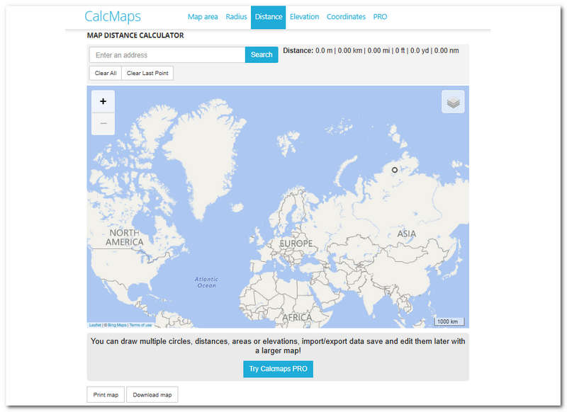
CalcMaps is a virtual map that allows users to calculate areas between two locations, and it can be accessed through a browser. This web-based tool is a distance calculator that allows users to draw multiple circles on areas or elevations within the map that show information about the location in meters, kilometers, miles, feet, yards, and nanometers. CalcMaps also allows users to enter a specific address through its search bar function, making finding the location hassle-free. One notable feature of this tool is its Map Radius Calculator, which allows users to draw circles at any location from the user’s Maps and with the use of a single click, it can extend or move the circle to seamlessly adjust and change the radius on the map/
Key Features
• Search bar functionality.
• Free calls and texts.
• Display various distance measurements.
• You can print and download the map for offline use.
• It has a record of the previous queue for easy history tracking.
• Clear all button functionality.
Part 2. How to Turn Off Location for System on iPhone
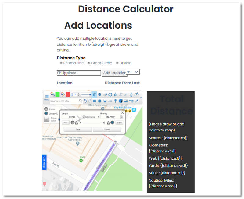
Another web-based map distance calculator is Scribble Maps, which has the tagline ‘make maps differently.’ This distance calculator can be used to view information specifically about the distance to any location in the world. This works by simply choosing a location between two points in the tool. Users need to calculate the distance they can easily measure between the two points by entering the location. Thus, the tool’s assistance greatly benefits those who want to measure distance in a straight line direction, a great circle distance that offers the shortest distance between points in the globe that involves the path an airplane would take, and a driving distance calculator that calculates distances between points using the route which vehicles are using.
Key Features
• Great area calculator.
• Simple interface tool.
• You can add multiple locations.
• Offers three distance types (Straight, Great Circle, and Driving)
• Search bar functionality.
• Support different distance measurements.
Part 3. Distance Calculator
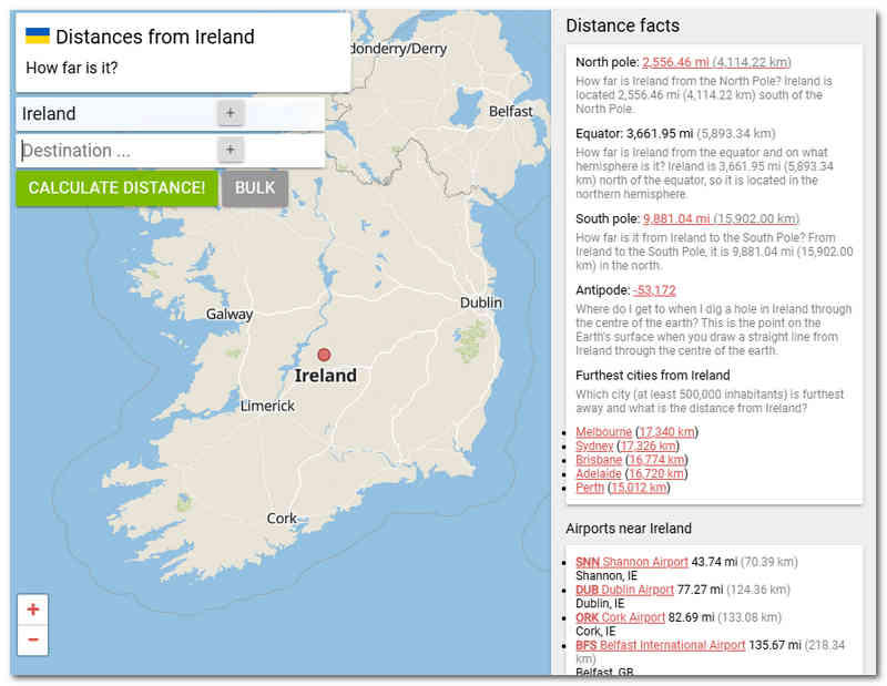
Distance Calculator is a web-based area calculator that can determine the distance between multiple points on a map by entering the desired location directly into the tool’s built-in search bar. It can be used as a land and flight distance calculator, giving the user the shortest distance between the selected points' coordinates (latitude and longitude). While it serves as an online-based location calculator, its uses expand to time differences or timezones which allows users to have accurate time information between different locations with different time zones. In addition, the Distance Calculator also has a feature that can identify the middle point between two locations. For example, when traveling between two places, users can estimate and view when they are halfway through their destination.
Key Features
• Distance or area calculator.
• It can be used to identify flight time & flight distance.
• Time zone or time difference calculator.
• Identification of midpoints between two locations.
• Supported a comprehensive list of country lists.
Part 4. Map Developers
Map Developers use another web-based distance information identifier or calculator with the same functionality as other distance calculator tools mentioned above. This tool can effectively locate and identify accurate distance information between multiple points using a long line. Alongside its accuracy in giving information to users about the distance, it is also capable of allowing them to draw a circle which can effectively be used when calculating or estimating location, but instead, it calculates the area within the circle instead of distance. In addition to the long line features within the tool, it can be used as an outline representing property, route, or hiking trail and as a walking distance calculator that can be easily shared with other users.
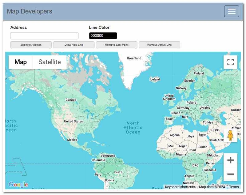
Key Features
• Customization of route line color.
• Search bar functionality of location.
• Remove the last point and active line from the map.
• Calculate the distance in different measurements.
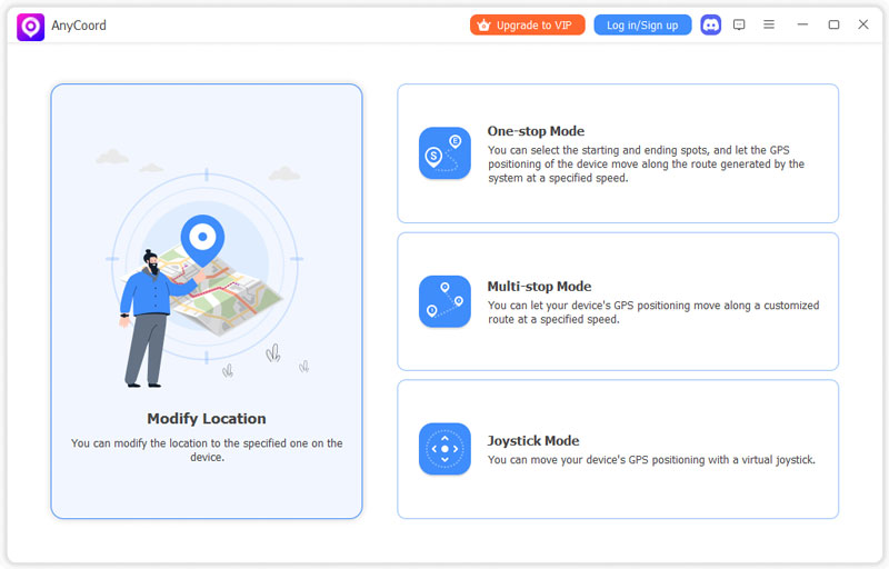
Part 5. AnyCoord
If you find using a web-based distance calculator a hassle, as its features are limited and it doesn’t allow you to customize a virtual location fully, then you will like AnyCoord. This tool is a program meant to be installed on your desktop devices. It is very lightweight and very easy to install. AnyCoord can easily calculate the distance, whether it is a real-time location or a virtual one. This tool uses modern technology and GPS systems that accurately pinpoint locations worldwide.
In addition, this program allows viewing the distance between multiple endpoints in a single go through its multi-stop mode, one of the four modes in virtual location settings. As a full-featured location calculator and changer tool, aside from fully displaying the distance information of coordinates and measurement, it can also be used as a speed distance time calculator, which shows estimated arrival on the endpoint. This works perfectly for calculating distances within a walking or driving distance range.
100% Secure & Clean
100% Secure & Clean
Key Features
• Full display distance coordinates.
• Shows the estimated arrival time between endpoints.
• Display accurate distance with accurate speed.
• Can customize route speed.
• Double function as a location switcher and distance calculator tool.
• Compatible with all platforms, applications, and location-based games.
• Create realistic movement on the selected route.
| Pros | Cons |
| • Full-featured distance calculator. • Accurately calculates distance. • Clean and safe software tool. • One-click location change features: You can change your location on social media, like Facebook. • Multi-device use support. • Search bar functionality for easy location search. • Four-mode virtual location features. • Lightweight software for desktop. | • Advanced features are available on a paid license. |
Verdict
• Unlike the web-based tool AnyCoord, it has a very easy-to-navigate interface. The program is well-organized, from its features to its buttons, even up to displaying information about distance and coordinates. Everything about the software is beginner-friendly.
• Its performance when calculating distance is without a doubt beyond the reach of the abovementioned web-based tool. AnyCoord gives an accurate distance between our selected point ends. While we are at it, it allows us to automate a movement and displays our estimated arrival time, which gives us more information on the distance we still have.
• One notable feature we recommend when you want to know distance while having multiple endpoints is using the AnyCoord built-in Multi-Stop Mode. This mode allows users to have various endpoints while accurately showing the distance information of each, speed, and estimated arrival time. This appears very helpful, especially when the task is just to calculate distance.
• While AnyCoord's usability has proven helpful in many ways, it doesn’t have a feature that allows users to give the shortest distance information involving air travel, like the Distance Calculator tool.
Part 6. FAQs about Distance Calculators
-
1Does Google Maps have a distance calculator?
Yes, features like calculating the accurate distance from one endpoint to another are possible in Google Maps. You can do so by right-clicking on the desired area and choosing ‘measure distance’ to display the distance between two or more location points.
-
2How to calculate the distance in km?
Most apps to measure distance or online-based tools support a feature that lets users switch distance measurements from km to ft, yard, and more. Usually, they have this arrow-down menu from their interface, and from there, you can select a measurement unit that is available to calculate your distance.
-
3How do you calculate my travel distance?
Simply enter your starting and end points on the distance calculator to calculate your travel distance. For this case, we recommend the AnyCoord tool. Once you have provided all the necessary information, the program will automatically show your total travel distance in walking, driving, running, and other modes of transportation.
-
4What is a distance calculator?
A distance calculator is a third-party tool that helps analyze or measure the total distance between locations input by users. Sometimes, it measures points between two locations, and some tools, like AnyCoord, can calculate two or more endpoints for versatility.
Conclusion
In summary, while a web-based online distance calculator gives convenient and easy access to accurate location calculators, a software-based tool gives users much control and more advanced features in terms of versatility in setting up a virtual location or simply knowing the distance between two or more locations. Like the AnyCoord, it is multi-use as it gives users access to a feature that is not limited to calculating distance but also helps users spoof and use a different location freely. Moreover, it is also important to note that the calculated distance, speed, and arrival time may sometimes appear different from what is displayed in your tool, as many factors can affect the distance and arrival time, such as heavy traffic in the location and more.


AnyCoord is the best tool to change, hide, or spoof your location in games, social media apps, and other apps on iPhone or Android devices.
100% Secure & Clean
100% Secure & Clean